Hardcore Parker
Lets go back to this summer…..

Standing atop Pyramid Peak
It was early August and after a wet early summer we finally had some serious heat and a lack of rain for a few weeks. I had just bought a specialty photography 50L overnight backpack that set me back a few hundred dollars. Might as well try it out!
As I scoured the All Trails app, the book “Trails of the wild Selkrik’s” and Google Maps I came across a long ridgline hike I thought I’d try my hand at. It’s located deep in the heart of the north part of the Idaho Selkirk’s. There are grizzly bear in this country and no water along the main ridge that goes for 20 odd miles gently losing and gaining elevation until you head down from Parker Peak. I decided to drop my car off at the start of the Parker Ridge trailhead and have my friend drop me off at the Trout Lake Trail. I would be doing a solo through hike of the area.

Getting a late start I climb with almost a full moon to my back up towards Pyramid Pass
Well I got a late start Friday evening and by the time I was hiking up the trail it was dusk. I’m no stranger to night hiking though and with almost a full moon I climbed up to the top of Pyramid Pass before finding a small spot near a large rock to camp for the night.

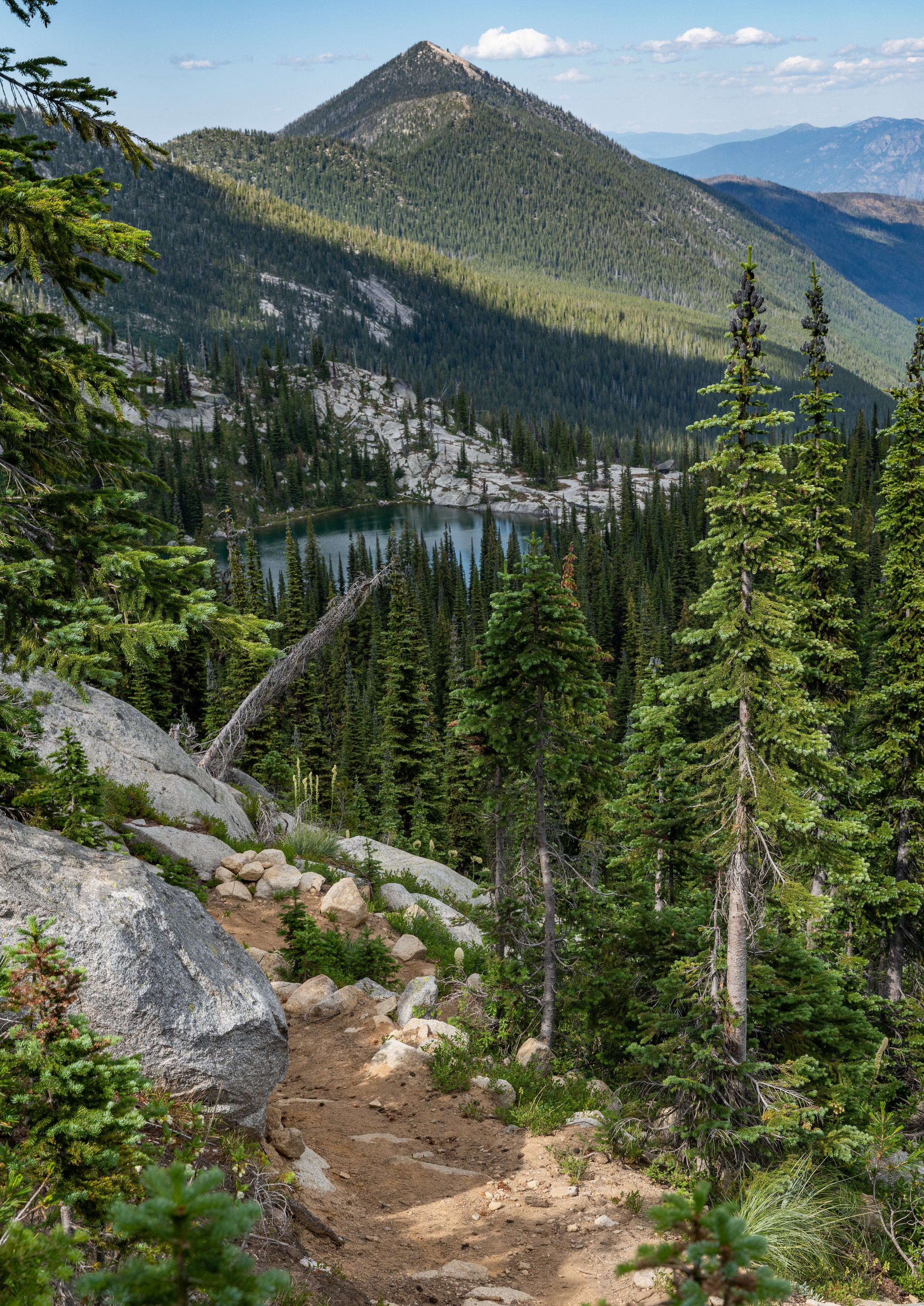
Looking at Pyramid Peak (what I had climbed a few hours earlier) from near the top of Parker Pass
Once I finally got up the next morning I made breakfast and did the off trail scramble to the top of Pyramid Peak from the pass. Even though I left a lot out of my pack it was still a bit sketchy in spots with a bigger pack scrambling up and down the mountain. I was glad I had just bought a Garmin Inreach satellite communication device in case something happened. I hadn’t seen a soul since starting the hike the evening before. I must say though the views from this peak are incredible! Some of the best i’ve seen in the Selkirk’s.
View atop Pyramid Peak
After breaking camp I began close to a mile long decent before then hard climbing for a couple miles to attain Parker Ridge. This would be the ridge that would eventually take me to my car.
I met a very elderly gentleman as I had stopped to take in some amazing wildflowers along the trail and he had caught up to me. Turns out he belonged to a group called “Boundary County Hikers” and let me tell you I found they are hardcore! This guy must have been 80 years old and he was out hiking me up the steep trail. He said he was going off trail to hike the unnamed peak to our right so that he could guide a group up there. Needless to say I was impressed. We parted ways atop the pass me going left and him going right, towards the peak.

Bumble Bee and Wildflowers along the trail before attaining the pass

As I was leaning over taking pictures of this butterfly I caught movement out of my eye and seen the old man was walking up the trail behind me

The view right when you attain Parker Pass. These boulders were massive
Getting up to the pass with a good 70 pounds on my back hadn't been fun but once I made it up everything was better. I walked along the ridgetop admiring views from all around and let the summer air fill my lungs. It was a perfect day! Soon I came to the Long Lake turnoff and I took that the mile or so down to the lake for lunch, to replenish my water, (I had not had a water source since yesterday evening), and rest my feet. The lake was much more beautiful than I had imagined it to be!
I met a father and son down there who were trying their luck with fly fishing. As we chatted for a few the dad mentioned his son (a young man probably 20 or so), had been getting eaten alive. They had not brought bug spray. I didn't have a whole lot but it was deet 100 so they didn’t need much. I gave them a few sprays to hold the insects off for the evening and then made my way back up to the pass.
Hiking down to Long Lake with an unnamed almost 7,500 foot peak in the distance

The amazing water of Long Lake
As I meandered along the pass I was in pure bliss stopping every few minutes to take pictures while my bluetooth player belted all sorts of songs from outlaw country, rock, to hip hop. I’m telling you the feeling I had up on that ridge in that short hour or two was better than taking the hottest babe in your school to prom. Okay at least the best looking girl from the town I came from, but I definitely digress there. Soon I came to this spot overlooking the far north and just had to stop and set the tripod up and throw the big 200-600mm lens on. With the naked eye I couldn’t pull details from the ridges that stretched on and on into Canada but with that lens it was another story…..

One of the views to my left before I stopped to set the tripod up

Looking into Canada shot on my 600mm lens

Again looking into Canada shot at 600mm. I call this one “Natures Geometry”.

Do you see the lookout tower?
After taking in the scene in front of me I continued on still enjoying the hike but knowing sunset was coming. I was still much farther from Parker Lake than I wanted to admit and looking at the unnamed mountain looming in front of me I realized I needed to make up time. I climbed about a mile before going off trail and climbing to the top of the unnamed giant. I wanted to hit every peak on that ridge!
It was dusk by the time I made it, wheezing the last stretch. I hadn’t taken the pack off for the ascent. I then hiked the quarter mile down the ridge to the camp site I found right after I went off trail. It was a blessing to have found a small patch of snow near my camp. I was to use it to melt into water beings I wasn’t making it to the lake anymore. That patch of snow and one just below it were the only places I found snow on the entire backpacking trip. A few days later and it would have been melted.

Idaho Moon on the way up the ridge at sunset before going off trail

Drone shot from on top of the unnamed peak. Do you see me bottom left of image?

I believe I was looking into Creston B.C. from the unnamed peak shot at 200mm

Milky Way from my campsite. The yellow on the tree is the light from my campfire
My camp was in a nice little flat area mostly surrounded by large rock so I was pretty protected from the wind. The snow patch was about a 50 yard walk away and I made a few trips making a lot of water for the long day ahead. The only issue is the water tasted of charcoal for some reason. Might have had to do with the snow I was using. Either way it was the only source of water I had at all so I could not be picky. I ate dinner, melted a lot of snow, wrote in my journal, and slept like a baby. Looking back I am glad I slept well even if it wasn’t that long.
The next morning I woke up early, melted even more snow, made coffee with honey my friend had given me, made breakfast and did devotions overlooking the high peaks across the valley from me. It was a perfect day and a ground squirrel decided to grace me with his presence for a bit. As I packed I knew it was going to be a very hot day without a lot of shade so I even filled my cooking tin full of snow and double bagged some snow to go. I filled a handkerchief with snow and put it around my neck, a trick my late grandma had taught me. Then I was off down the trail. It was already 10:30am and I had what I thought was 13 miles to go.

Ground squirrel at my camp

My view for devotions

Looking at Chimney Rock and mount Roothaan shot at around 500mm from camp

The swamp about 1000 feet straight below my camp. Look at the maze features on the bottom left of image
I hiked quickly and even had enough service to call my dad and grandpa for a couple minutes at one point. Then the trail dropped and climbed again. It took me past the turn off to Parker Lake and then at its highest I could go left on the trail that would take me up to the top of Parker Peak. This is the second highest point in the Idaho Selkirk’s and the highest named point. I decided to do it. After all I wanted to hit every high point remember? I set my heavy pack down after the first half mile and finished the climb with my camera and drone in hand. Parker Peak sits almost 6,000 feet above the Kootenai Valley! From on top though it doesn’t seem that far to get down but let me tell you in this case looks are most definitely deceiving. I flew my drone for a bit, wrote in the peak registry, and then made my way back down to my pack before eating lunch and rehydrating in the shade. I thought the hard part of the day was over but something in the back of my mind was telling me to be prepared to not stop even when it got harder.

Looking down on Parker Lake from Parker ridge

You can see the top of Parker Peak is about two miles away here

Looking into the Kootenai Valley and Creston B.C. from the top of Parker Peak

With arms wide open, under the hot sun. Drone self portrait from the top of Parker. Can you see me on the peak?
Drone footage from atop Parker Peak
Once I got back on the main trail heading down the long ridge I had about 9 miles to go according to my calculations. Let me tell you I had all 9 and more. After about a mile you come to the side of Parker Peak but about 1000 feet below the top and there are sweeping views of the large granite cliffs along the side of the peak. At this spot I ran into a through hiker heading the way I had came who was doing the PNT. He said I had about 8 miles to go still according to his watch. I only had about 3 hours of daylight left which should have been enough I thought. This would be the last person I would see on the trip.
At one point the trail decided to climb again for about half a mile. I was so exhausted from the days hike so far and the 70 pound load on my back I couldn’t even make it the half mile before plopping on the ground with a near heave. I was worn out. But I got back up and kept going. At this point my feet had developed minor heat blisters. Those boots were not the best for that kind of distance. Soon I entered a massive old burn and followed the mostly flat but slightly downhill trail mile after mile.

Part of the granite wall you encounter on your way around the peak

Looking down at Kootenai Valley

Cause I’m leavin’ on a jet plane

Don’t know when i’ll be back again

I just had to walk a little off trail to take a picture of this oddly shaped burnt bark
Soon every step started to become painful and despite walking at a decent pace I wasn’t making the fastest time as I just had to stop a few times to take photographs. This is a dilemma I seem to face constantly as a photographer. I never want to pass up a photo opportunity!
Anyhow although the hike through the burnt forest was beautiful in its own right it seemed like it took forever and just before the trail started into its relentless switchbacks going down the sun had set. Well according to my calculations I only had three more miles to go so hiking that far in the dark shouldn’t have been that hard. I passed the only tiny trickle of a water source on the entire trail and was in such a hurry I didn’t stop to fill up. This was a major mistake as about an hour after that I was completely out of water and I thought I was a mile and a half closer to the car than I was. The night was sweltering on that dry ridgline and a warm wind was blowing up from the valley below further dehydrating my already parched tongue. Mosquitoes wouldn’t stop biting my arms and shoulders even as I would spray myself with deet my sweat would soak over it. I still had 3,000 vertical feet to drop after the watering hole.
The trail switched back and forth back and forth and my toes and heels shot with pain every step. I’m telling you this trail just didn’t let up!

Last rays of the day on the mountain behind me

Moon and last sun hitting the ridge across from me

Kootenai River Below

A little more zoomed in

Look at all the downed trees from the fire. I still had almost five miles to go from this spot.
Well I found out a bit further down when my calculations told me I was supposed to be at the car I had been wrong. I believe the through hiker was off as well and I had not calculated the extra two to three miles it took me to do Parker Peak. I am not lying when I say at this point every step was almost agony and as the sweat made my back soaked I wished for water. It ended up being almost two more miles before I broke out onto the road and seen my car. I had stashed a water under my seat full well knowing I had a high chance of being out and dehydrated by the time I would get there. It was after midnight at this point as I finally made the hour long drive home stopping on the way at Super 1 in Bonners Ferry and buying a large amount of food and drinks. Thank God for 24 hour grocery stores!

Yep I was a tired boy
I have hiked and ran further than this day on a few occasions but this is still the hardest day of hiking I have ever done. Maybe it was the 70 pounds on my back combined with the two days of tent sleeping before? Or the lack of proper foot-ware and the heat and dehydration combined with all the work it took to just make water out of snow. I think all those things had something to do with it. Either way you now know why I chose to name this post “Hardcore Parker”. It certainly has nothing to do with an episode of a popular T.V. sitcom…..