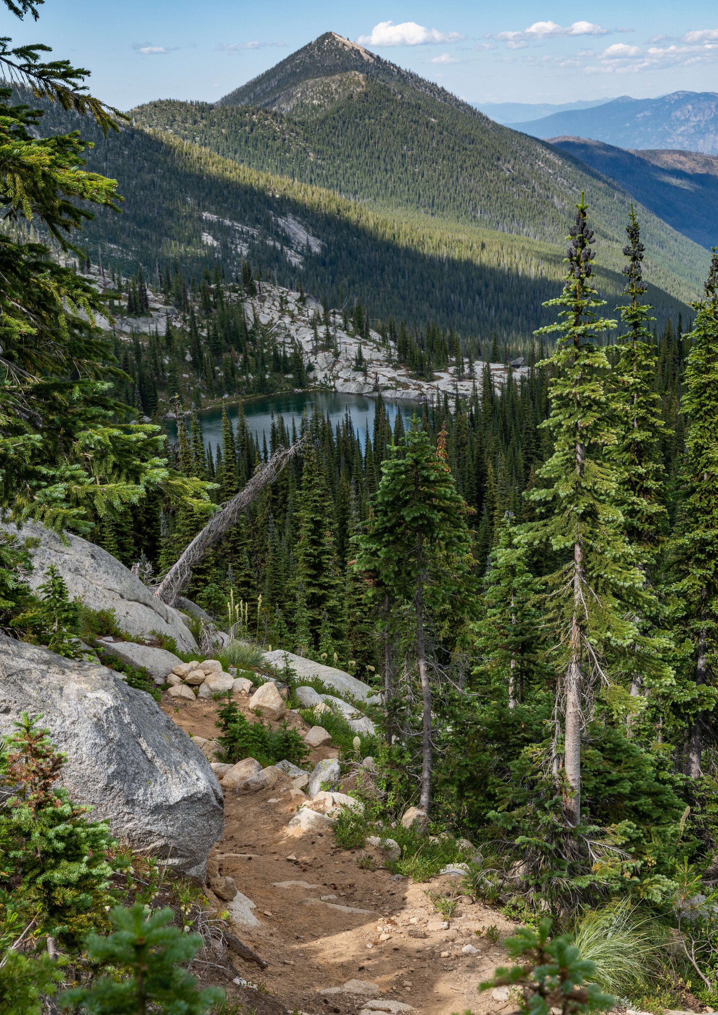
Into the Shroud - Adventure in Glacier Park
Mid July 2025 I ventured into Glacier Park after spending a few days with family and friends in the Libby and Kalispell areas. There was a cold front moving in, with a chance of snow above 8000 feet. Perfect! Entering going to the sun road around 3:30 PM it was sunny and warm. But as I climbed, moving clouds hung to the higher peaks in the center of the park. A couple miles from Logan Pass I had entered a thick, foggy shroud. It was hard to see at times as I made my way into the parking lot.

Mount Oberlin makes a brief appearance in the clouds as I head up Going to the Sun
People were scurrying about in the fog, many with shorts and flip flops on. A pretty interesting sight. I seen one family hiking away from the parking lot and arrive back about 20 minutes later with their adolescent boy shivering in his gray hoodie, hood scrunched up around his face. Apparently some had not prepared themselves for mountain weather changes. I got ready and headed up the highline. It felt a bit of a wonderland in the fog with the foliage, ground squirrels scampering around, and feeling all alone on the trail. I ended up only passing a few souls that entire evening. I seen a solo tree in a field of flowers and took a shot. This image ended up being one of my favorites from that day, well besides the animal encounter, but we’ll get to that!

Hiking down the highline trail near Logan Pass conditions were dynamic changing on a dime

A single tree stands as a testament in a field of flowers

Vehicles make their way up Going to the Sun in a surreal display of conditions

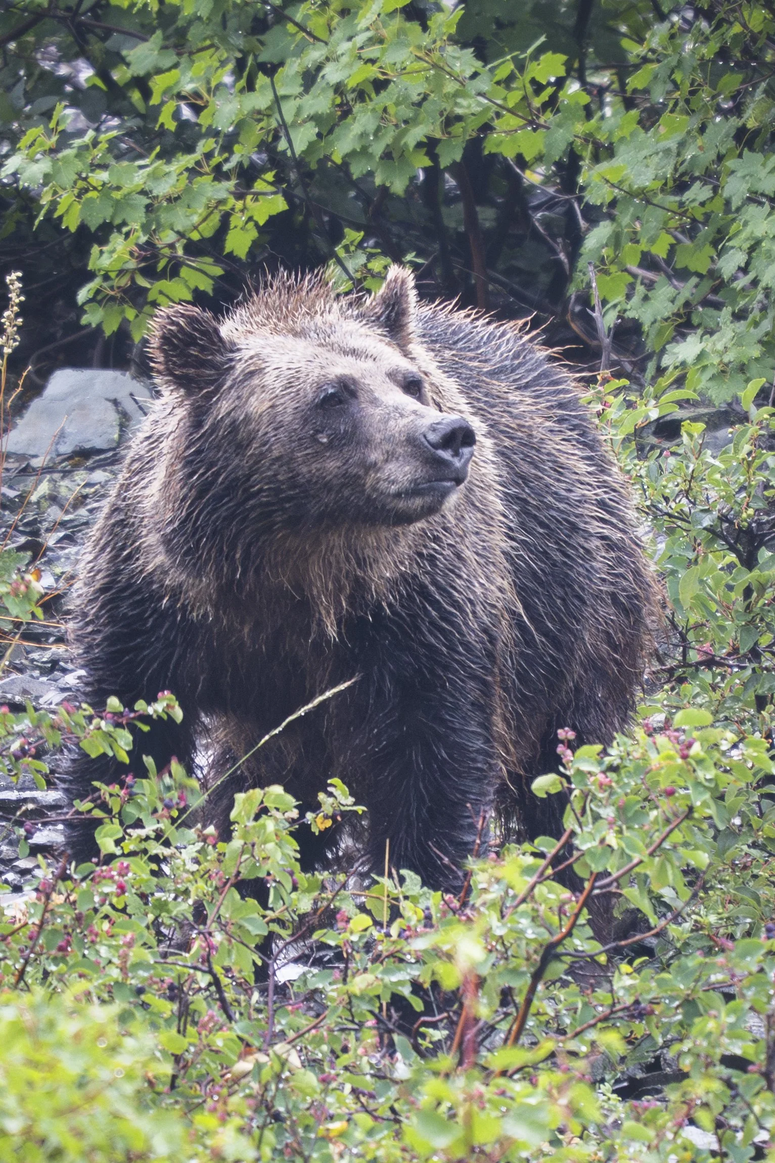
As I went further up I met a couple who said a big horn sheep was less than two more miles up the trail. I was very excited about this with the way the conditions were in the light rain and diffused light. Further along the trail I asked the others I passed and the reports kept getting closer! When I passed one last hiker, who was resting on a rock, slouched over and exhausted from a long day of hiking uphill. She said he was only 1/4 mile further on! I made sure the young lady was okay before proceeding, then shortly after stopped and threw my 200-600mm lens on my camera and dialed in my settings. I was ready! And there he was a bit further on. I spent over an hour photographing this majestic beast even capturing some video footage Im excited to share with you all at some point. Then it was a hike back, arriving at my car just as the last bit of light faded. Time to go find somewhere to sleep!


I actually really enjoy this image of him peering through the brush

As I drove towards Saint Mary’s it began raining and then down pouring! I found a spot near town to park my car. I had to make dinner under my hatchback roof because of the storm and sleeping in my car that night was not my most favorite experience as sideways rain kept coming into my small window crack landing on my face. Finally I completely closed the windows and got a bit better sleep. I slept way in, went into town and had breakast at a local spot before heading back up towards Logan Pass. The weather was supposed to clear mid afternoon and I wanted to catch sunset at Hidden Lake.
A few miles into the park I passed a pullout with someone looking towards the mountain across the road. I knew what this could mean so turning around I pulled in. A grizzly bear was 100 yards up the hill! It was foraging on the numerous “service” berries covering the area. Soon the entire pull out was full of cars and then more! A major traffic jam had started and park rangers were monitoring the scene yelling on loudspeakers orders for us to “stay off the road”. It was quite the sight. I spent about 45 minutes photographing and making friends before heading up again towards the pass.
A grizzly forages for berries
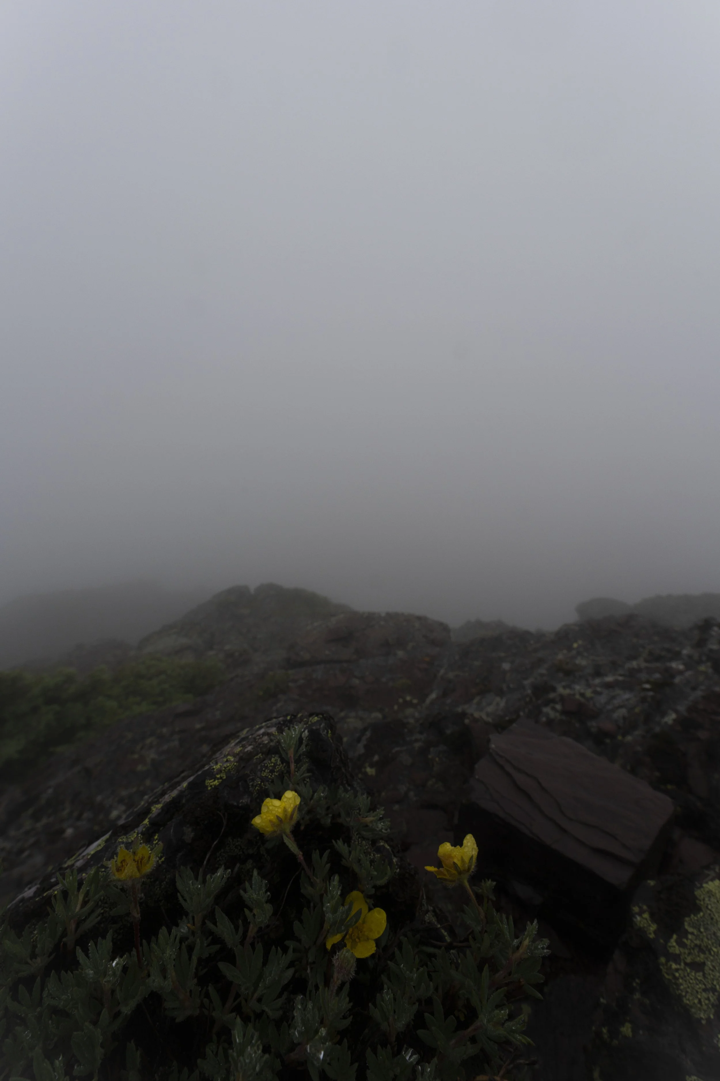
Atop the pass the fog was as thick as ever! I ate some lunch, packed my bag, and headed up towards Hidden Lake Lookout. Along the way I spotted some scenes I couldn’t help but photograph.

The beginning of the hike I found myself in clouds and flowers

Indian Paintbrush is very vibrant at alpine elevations


Upon reaching the lookout spot there was not much to see. Heavy blankets of fog covered what was the lake below. I asked the man of a rather large I assume family group to take a picture of me to document it. We chatted a minute and then I walked off, in search of a good place to photograph sunset if the fog burned off. I wanted something decent for my foreground (close part of image) and different than the lookout spot. I wandered about and eventually decided to climb the small mountain close to the lake. The fog was heavy and never let up. So right around sunset I made my way back to the car and then drove to Saint Mary’s.


Looking down towards Hidden Lake. On this day I understood the name.

The fog did clear enough to see the lake on a couple of occasions, but not enough for sunset where I ended up.


I photographed this image about 30 minutes before sunset near the top of the unnamed mountain. This is near where I took the image the next day you will see reading further. You can see how much conditions can change in a short amount of time.
I didn’t get much car sleep, more of a short nap, before I noticed the clouds moving away and a moon shining on me. Soon it would be time to make my way back for sunrise. Around 2:45 am I was up and moving about. Then it was the drive up to Logan Pass and the same hike up the mountain I had done hours before. But this time there were clear skies. Brilliant stars gleamed about and reflections from the moon of fresh snow sat atop some of the mountains. I was hoping the fog would burn off in the morning rays, creating beautiful photographic conditions, but one cannot change the weather and I was happy for a different climate. Soon dawn approached as I made the last steps to the summit. I chose a spot I liked that had a foreground of alpine trees creating a neat frame around Hidden Lake and Bearhat Mountain. It was calm as it began to get light and blue hour created a beautiful reflection of the mountain on the lake. Although fairly exhausted my spirits were up being able to see the landscape around me.
I setup my tripod in a pretty intense spot, overhanging a 5 foot cliff, and prepared my camera. This morning I decided to shoot 3 shots in different exposures for every frame. Even with modern technology in cameras I wanted to make sure I did not blow any highlights out while still keeping my shadows bright enough. When the sun hits one area and the rest of the frame is in dark shade, it creates harsher light conditions so it helps to know ones equipment and how to use it. And then I waited. As the sun came up I periodically snapped images as light moved down the mountain, I was patient that day and not moving my camera from its location, a testament to growth on my part. But at one point, a bit after sunrise, I did go on a short jaunt to catch some images facing the sun.

Dawn

Sunrise

You can see the sun moving down “Bearhat” Mountain

Facing more north in the opposite direction

Looking NW towards Clements Mountain
There was a lot if waiting that morning after the sun came up. At one point after sunrise I laid down and took a short nap on the scree, waiting for the sun to torch the top of the trees just how I wanted. Then when it happened I had an idea! I put my camera on its intervalometer (basically a time-lapse setting). I wanted an epic self portrait! Trying a few poses I found one I liked and “Photo Assassin” was born. Funny, I had never planned or even thought of taking an image like that until minutes prior. I have found many of my favorites are when I let the shot come it me, instead of forcing something that may or may not happen. That is how this morning went. The weather did not happen as I had hoped, so I got creative and came away with something I am proud of. Such as in photography as in life.
Nap time

“Photo Assassin” Self Portrait. This shot reminds me of the popular video game series “Assassins Creed”
Soon after “Photo Assassin” I made my way back down. Hidden lake trail was full of people and I was “jamming out” with my headphones in as I sped may way to the car. Then it was down the pass and into the valley. I took a nap at Lion Lake and met up with some friends after, eventually arriving at my North Idaho home in the wee hours of the morning. What an adventure!
Aurora chasing in Montana’s Cabinet Mountains Wilderness
It’s been a bit since I’ve wrote in here. Life has been interesting, doing many things, work wise and ministry. Recently I went on a couple of grand adventures in the Cabinet Mountains Wilderness of Montana. I want to tell you about one of them!

A mountain goat watches me on some rocks above the Leigh Lake Trailhead
The Cabinets are my home range, where I fell in love with the outdoors and photography as well. The last weekend in May the aurora was supposed to be out. I planned to get a dream shot over Leigh Lake. Having never been up above on the south side I ventured out that Sunday evening, the first day of June, after helping my grandpa with some spring cleaning. He still lives in Libby.
Anyhow things started out smoothly. I seen a solo billy mountain goat and some young ones further on closer to the lake as well. They were pretty stinkin’ cute. Then I came to the creek crossing. This was my first major obstacle. I could not cross where I had planned. It was pretty high and I had to do some minor bushwhacking to find a safe place to proceed. Taking my shoes off and using all fours at times for balance I made my way across without falling. Gear and shoes dry! But let me tell you the pain from that cold water in my hands and feet was excruciating for about 30 seconds after I made the other side!

Baby Mountain Goats

This is only a small part of the raging creek
From then on it was all off trail scrambling and about 2000 feet of elevation gain to my destination. This was my first major steep hike of the season and my legs felt it!! But let me tell you when sunset approached I didn’t notice my legs anymore. Beautiful tangerine colored clouds kept spilling over snowshoe peak, the tallest in the cabinets. I kept stopping and finding compositions to take pictures of it. And it lasted a long time!

Sunset high above Leigh lake with clouds spilling over Snowshoe Peak


Those colors were fabulous
As darkness grew I attained the ridge and stopped for a minute. It was then I noticed something catching in my throat. I began to cough and clear my throat excessively. Now I was worried I was having an allergic reaction to something way out there in the dark, alone off trail. But walking towards my pack I heard a faint sound of air coming from my shoulder pad where my bear spray was kept. There was a small hole in it and it was leaking out! Somewhere down below in my scrambling I had hit it on a rock! At least I knew now I was safe. Just uncomfortable and had to clean up a mess! Then I saddled up and made the upper ridge in about another half hour of hiking. There was between 3-10 feet of hardpacked snow on the ground most places still! And a bit eery up there. I found several crevices and a couple smaller caves in the area as well. Not what I was expecting, but cool nonetheless.

The moon just after sunset. The high country has clean skies that really show the moon off
At this point I was exhausted, having been up all night the evening before chasing the Northern Lights and taking a couple of naps that day to ward off the dreariness. But it was upon me hard now! And things did not look good for the aurora. Being up so high I had some service and the forcast to see any was bleak. I did not bring a tent but found a bare spot of ground under an ancient alpine larch and made my bed, moving some of the larger rocks out of the way. I was a bit scared, having never been there and my first night out alone of the year. Realizing I had not read the Word that day I opened up the Bible app. I rarely check the verse of the day but looked just then. It was Joshua 1:9 “Be strong and courageous! Do not be afraid or discouraged. For the lord your God is with you wherever you go”
It was after midnight now and with that passage my trust was enough to close my eyes and drift off….
Sometime in the wee hours I felt something jump on my belly! A small rodent of some kind! Freaking out I awoke yelling in tongues as the animal hopped off me and scampered into the night. Almost as if it was a dream, I was not completely sure it had happened as I drifted back to sleep. An hour or so later I woke up and glanced at my phone. Aurora alert!! Peering as close to north as I could with the small cliff next to me there it was! A bright green line stretching across the horizon! It was 3:00 am. Only an hour until the first light of dawn would hit! And I had no composition ready. I had to move fast!
Now let me tell you a little something about the human experience in a situation like this. Barely any sleep, pitch black moonless night (it had dropped below the horizon), high up on a ridge I have never been on before with old snarled trees and random caves and drop offs around me. Trying to find a place that adequately shows off the lights and the environment. Am I setting the scene enough? I unzip my sleeping bag, throw all my layers on (it is cold), boot up and throw my pack and headlamp on. Venturing into the blackness using my topo map, satelight map, and whatever my eyes can see I make my way along and down the ridge. Seeking something distinctive! I find an old snarled snag and set up. A couple of shots in I decide I want something else and hiking back up the ridge line making it to camp. There, just 100 feet on the other side of that small cliff is where I found my spot! Just as the first light of dawn hit the eastern sky, the northern lights grew the strongest, purples and greens stroked across the night like a large paintbrush, and I captured a moment in time.
Oh and that rodent? I seen it later that morning. It stared at me before running to its home, only a few feet from my sleeping bag. Turns out as I was romping around that early morning chasing the lights it had came back, and chewed many small holes in my bag.
I made my way back down to the lake and relaxed a while there, before heading back down the trail and back to Libby. And then to my home in North Idaho. A worthy trip with new memories of a godly expenditure.
The last aurora image is available as a print and I am considering doing it as a limited edition. For information on that please email me. Thank you for reading along. I hope you all have had a great start to summer.
God bless you and may your days be filled with wonder and a sense of knowing there is more than what we see in our lives.
P.S. It turns out as I got back into civilization I read that the aurora experts put out a late night report that the states in the far northwest US could experience the lights right at dawn. The east and midwest would already be way to into the morning to see them if they hit. Talk about being at the right spot and moment in time!

What I first seen when I woke up

The old gnarled snag, Snowshoe Peak, “A” Peak, and Bockman Peak. This image is not quite finished yet but I wanted to share

As dawn rises in the east the lights make a mad dash of showing off the darkness

Early morning near my campsite

An ancient white bark pine catches the first rays of the day
Winter Snowshoe into Crater Lake National Park
The sun begins coming out on Garfield Mountain. You can see the avalanche shutes on it and that is why I did not go the normal trail route located at its base.
It was early December and I had some free time. The woman I was interested in at the time was visiting a friend in San Jose and had invited me to join. I checked the plane tickets and they were more than I wanted to spend. So what did I do??? Well naturally what you all are used to me doing. I made my bed in my Subaru and took off down the road. It was quite the trek just getting to my first destination as I was in the front of one snow storm at the beginning and the tail end of another by the time I arrived in Bend, Oregon. After arriving I got about three hours of sleep in a cheap but very accommodating hotel I found. This was to avoid another fitful night sleep in my car like I had the previous day at a rest stop somewhere in the Eastern Washington wasteland some would call the most boring stretch of I90 known to man. But I digress. This story is about my short but intense experience with the deepest lake in the United States. Crater Lake!

Dawn just after arriving at the park. It was pretty socked in. In the distance you can see the avalanche shutes on Mount Garfield
Crater Lake looks exactly how it sounds and was formed by a massive volcano. In fact, the rim is a thirty mile hike just to get around! But before telling you all the features, and thus spoiling my story, I shall now continue the tale of this magical place. I woke up in the hotel just after 4:00 A.M, packed my car, and headed south. The roads were snowy but straight and I was about the only car on the road beings it was an early Sunday morning so I made great time. Once I turned off of highway 97 I began to slowly climb and the snow got deeper and deeper. As I neared the park the road was down to a near single lane and there was so much snow on either side it was almost like driving in a tunnel in the dawn light. I made it in the park but soon realized I would not be driving to the rim. The last two miles of the road were gated and completely snowed in! To make it worse there were signs stating nobody could ski or snowshoe in on the road begins plowing could commence at any time. What could I do now? I was stuck less than a mile as the crow flies from my photo destination!
The drive as I got closer to the park entrance
To top things off even more there was like no parking anywhere. So I did what any North Idahoan would. I backed my car right into the main ranger stations parking lot. Soon I had my gear, snowshoes and just about everything else packed or on. A couple rangers walked by and I had a quick chat. Turns out there was avalanche danger but the ranger told me a way to go to avoid any issues. He also told me the only place I could really park. A tiny pullout literally on the side of the road before the gate. Very odd to me for being a National Park but what can they do with literally three feet of fresh power? The parking lot beyond the ranger station where most of the rangers kept their cars parked was completely snowed in so most of them couldn’t even go anywhere. It was a chaotic peaceful mess of winter wonderland.

When you look up
As soon as I set out I realized this was going to be quite the undertaking. My feet went one to two feet down into the powder with every step! It took me an hour just to get to the end of the completely snowed in campground. The only other tracks were a few sets of bunny prints. It was a world of fresh white and I was the intruder.

Lots of snow! This was at the end of the campground
The cabin at the end of the campground before heading up the hill. This shows just now much snow I was in!
Soon after reaching the end of the campground I went straight up a two hundred foot hill. Now any other time two hundred feet of vertical would be nothing to me. But in this incredibly deep snow it was a frozen hell of slipping backwards, having my snow shoes sending snow flying up my back from my extreme efforts to not slip down the hill as I climbed, and random spots where I would sink down farther than others just making it super awkward to climb. From my map I could see I would be approaching the road soon and I would have to cross it to continuing my trek.
The Hill!
After finally attaining the lip of the hill and seeing the road buried in snow below I had to make a choice. I could hear the plow coming. I thought maybe to wait for the plow and hike along the side of the road as it could be more compact snow. So I waited. As the plow approached I realized it wasn’t much of a plow but rather a massive snow blower and I was going to get buried in snow as it was shooting powder one hundred feet towards the side I was on! I retraced my steps part way down the hill, turned my back towards the blower, threw my coat over my body, and hid my camera in my chest. Then it was a world of white for about three seconds. Not as bad as I was expecting and I laughed out loud at the ridiculousness of it all. It just struck me funny what I was doing out there getting pounded by a massive snow blower. I had turned on my video on my phone to record it but somehow bumped the stop button in the hurry to get in a good and safe position just before the power went flying over my head. To this day I wish I could have seen that footage. The side of the road turned to be a soft and horrible go so I crossed the road and continued on my original route.
Took this video shortly after crossing the road
The trees were just so pretty I had to take a video
Well after I hiked across the road I started making better time about another quarter mile farther as I finally reached the top of the steeper vertical climbing. During this time the sun finally came out. It was glorious! The total vertical gain from this hike was around 700 feet. After it leveled out some the snow was a bit more compact so I was only falling about 6 inches most steps. Soon the sun began to get socked back in but I could see the lodge that is only open in the summer and then I was at the rim!! That first glimpse coming up over the rim looking straight at wizard island as the remaining rays still struck it was awe inspiring! The water is a deep blue color unlike I had ever seen before. They say its the clearest water in the world! But I still had to climb the rim up towards Garfield Peak, the mountain the avalanche danger was from. I felt safer in the rim area though as the avalanche shoot was south of me. I made great time until the last portion where I was literally digging 3 feet down for every step for a few minutes! But then I was in the spot I wanted. It had taken me nearly five hours to go less than two miles but I had made it! I could see the entire lake and 30 mile rim around it. It was absolutely spectacular! And I was the only one in the entire area besides the snow plow driver way down below me on the road. But then he was gone too and it was just me and God.

Panorama along the rim. Wizard island is in the distance.

That’s some deep ass snow! This is the part I talked about having to dig down for each step.

Staying warm behind the rock

Getting socked in
Don’t look down

The lodge as seen from my final destination. Look very close. Can you see my tracks?

Massive panorama of Crater Lake from my final destination

Just after sunset
I sat up there for hours, at times huddling next to the large rock for warmth and others climbing the rock braving the heights for another set of panorama shots over the lake. I had much difficulty from condensation ice forming on my lenses but managed to pull off some shots in between. I almost left before sunset as I was getting socked in with fog and snowfall but I felt the Lord tell me to just spend some time doing my devotions with Him. Because I obeyed that prompting I was able to see it clear up 20 minutes later and the sun danced all over the other end of the lake. I stayed till after sunset taking many images and hiked down in the dark. I had 9 percent battery on my phone when I got back to the car and it was my only source of light as I had never planned staying out past dark. I had been paying attention to my battery life but a great lesson to always bring an extra light no matter what.
Shortly after reaching my car a ranger pulled up. My beard was iced over so I must have looked interesting. He goes “are you alright”. I said very calmly “yeah man I am fine”. And truthfully I was and actually super warm from the hike down. He says “we thought we were going to have to go find a dead body tomorrow”. I told him since it was such a hard hike I had decided to stay and wait out the sunset. I guess they had been getting worried when I didn’t show for dark. Funny though I had full service up there and could have answered a call if they needed reassurance. I apologized repeatedly to him and we made some good small talk, then I headed on down the road. Off to San Jose with tank top and short’s kinda weather!
Shooting the sunset

Right around sunset

Following my tracks out
Hardcore Parker
Lets go back to this summer…..

Standing atop Pyramid Peak
It was early August and after a wet early summer we finally had some serious heat and a lack of rain for a few weeks. I had just bought a specialty photography 50L overnight backpack that set me back a few hundred dollars. Might as well try it out!
As I scoured the All Trails app, the book “Trails of the wild Selkrik’s” and Google Maps I came across a long ridgline hike I thought I’d try my hand at. It’s located deep in the heart of the north part of the Idaho Selkirk’s. There are grizzly bear in this country and no water along the main ridge that goes for 20 odd miles gently losing and gaining elevation until you head down from Parker Peak. I decided to drop my car off at the start of the Parker Ridge trailhead and have my friend drop me off at the Trout Lake Trail. I would be doing a solo through hike of the area.

Getting a late start I climb with almost a full moon to my back up towards Pyramid Pass
Well I got a late start Friday evening and by the time I was hiking up the trail it was dusk. I’m no stranger to night hiking though and with almost a full moon I climbed up to the top of Pyramid Pass before finding a small spot near a large rock to camp for the night.

Looking at Pyramid Peak (what I had climbed a few hours earlier) from near the top of Parker Pass
Once I finally got up the next morning I made breakfast and did the off trail scramble to the top of Pyramid Peak from the pass. Even though I left a lot out of my pack it was still a bit sketchy in spots with a bigger pack scrambling up and down the mountain. I was glad I had just bought a Garmin Inreach satellite communication device in case something happened. I hadn’t seen a soul since starting the hike the evening before. I must say though the views from this peak are incredible! Some of the best i’ve seen in the Selkirk’s.
View atop Pyramid Peak
After breaking camp I began close to a mile long decent before then hard climbing for a couple miles to attain Parker Ridge. This would be the ridge that would eventually take me to my car.
I met a very elderly gentleman as I had stopped to take in some amazing wildflowers along the trail and he had caught up to me. Turns out he belonged to a group called “Boundary County Hikers” and let me tell you I found they are hardcore! This guy must have been 80 years old and he was out hiking me up the steep trail. He said he was going off trail to hike the unnamed peak to our right so that he could guide a group up there. Needless to say I was impressed. We parted ways atop the pass me going left and him going right, towards the peak.

Bumble Bee and Wildflowers along the trail before attaining the pass

As I was leaning over taking pictures of this butterfly I caught movement out of my eye and seen the old man was walking up the trail behind me

The view right when you attain Parker Pass. These boulders were massive
Getting up to the pass with a good 70 pounds on my back hadn't been fun but once I made it up everything was better. I walked along the ridgetop admiring views from all around and let the summer air fill my lungs. It was a perfect day! Soon I came to the Long Lake turnoff and I took that the mile or so down to the lake for lunch, to replenish my water, (I had not had a water source since yesterday evening), and rest my feet. The lake was much more beautiful than I had imagined it to be!
I met a father and son down there who were trying their luck with fly fishing. As we chatted for a few the dad mentioned his son (a young man probably 20 or so), had been getting eaten alive. They had not brought bug spray. I didn't have a whole lot but it was deet 100 so they didn’t need much. I gave them a few sprays to hold the insects off for the evening and then made my way back up to the pass.
Hiking down to Long Lake with an unnamed almost 7,500 foot peak in the distance

The amazing water of Long Lake
As I meandered along the pass I was in pure bliss stopping every few minutes to take pictures while my bluetooth player belted all sorts of songs from outlaw country, rock, to hip hop. I’m telling you the feeling I had up on that ridge in that short hour or two was better than taking the hottest babe in your school to prom. Okay at least the best looking girl from the town I came from, but I definitely digress there. Soon I came to this spot overlooking the far north and just had to stop and set the tripod up and throw the big 200-600mm lens on. With the naked eye I couldn’t pull details from the ridges that stretched on and on into Canada but with that lens it was another story…..

One of the views to my left before I stopped to set the tripod up

Looking into Canada shot on my 600mm lens

Again looking into Canada shot at 600mm. I call this one “Natures Geometry”.

Do you see the lookout tower?
After taking in the scene in front of me I continued on still enjoying the hike but knowing sunset was coming. I was still much farther from Parker Lake than I wanted to admit and looking at the unnamed mountain looming in front of me I realized I needed to make up time. I climbed about a mile before going off trail and climbing to the top of the unnamed giant. I wanted to hit every peak on that ridge!
It was dusk by the time I made it, wheezing the last stretch. I hadn’t taken the pack off for the ascent. I then hiked the quarter mile down the ridge to the camp site I found right after I went off trail. It was a blessing to have found a small patch of snow near my camp. I was to use it to melt into water beings I wasn’t making it to the lake anymore. That patch of snow and one just below it were the only places I found snow on the entire backpacking trip. A few days later and it would have been melted.

Idaho Moon on the way up the ridge at sunset before going off trail

Drone shot from on top of the unnamed peak. Do you see me bottom left of image?

I believe I was looking into Creston B.C. from the unnamed peak shot at 200mm

Milky Way from my campsite. The yellow on the tree is the light from my campfire
My camp was in a nice little flat area mostly surrounded by large rock so I was pretty protected from the wind. The snow patch was about a 50 yard walk away and I made a few trips making a lot of water for the long day ahead. The only issue is the water tasted of charcoal for some reason. Might have had to do with the snow I was using. Either way it was the only source of water I had at all so I could not be picky. I ate dinner, melted a lot of snow, wrote in my journal, and slept like a baby. Looking back I am glad I slept well even if it wasn’t that long.
The next morning I woke up early, melted even more snow, made coffee with honey my friend had given me, made breakfast and did devotions overlooking the high peaks across the valley from me. It was a perfect day and a ground squirrel decided to grace me with his presence for a bit. As I packed I knew it was going to be a very hot day without a lot of shade so I even filled my cooking tin full of snow and double bagged some snow to go. I filled a handkerchief with snow and put it around my neck, a trick my late grandma had taught me. Then I was off down the trail. It was already 10:30am and I had what I thought was 13 miles to go.

Ground squirrel at my camp

My view for devotions

Looking at Chimney Rock and mount Roothaan shot at around 500mm from camp

The swamp about 1000 feet straight below my camp. Look at the maze features on the bottom left of image
I hiked quickly and even had enough service to call my dad and grandpa for a couple minutes at one point. Then the trail dropped and climbed again. It took me past the turn off to Parker Lake and then at its highest I could go left on the trail that would take me up to the top of Parker Peak. This is the second highest point in the Idaho Selkirk’s and the highest named point. I decided to do it. After all I wanted to hit every high point remember? I set my heavy pack down after the first half mile and finished the climb with my camera and drone in hand. Parker Peak sits almost 6,000 feet above the Kootenai Valley! From on top though it doesn’t seem that far to get down but let me tell you in this case looks are most definitely deceiving. I flew my drone for a bit, wrote in the peak registry, and then made my way back down to my pack before eating lunch and rehydrating in the shade. I thought the hard part of the day was over but something in the back of my mind was telling me to be prepared to not stop even when it got harder.

Looking down on Parker Lake from Parker ridge

You can see the top of Parker Peak is about two miles away here

Looking into the Kootenai Valley and Creston B.C. from the top of Parker Peak

With arms wide open, under the hot sun. Drone self portrait from the top of Parker. Can you see me on the peak?
Drone footage from atop Parker Peak
Once I got back on the main trail heading down the long ridge I had about 9 miles to go according to my calculations. Let me tell you I had all 9 and more. After about a mile you come to the side of Parker Peak but about 1000 feet below the top and there are sweeping views of the large granite cliffs along the side of the peak. At this spot I ran into a through hiker heading the way I had came who was doing the PNT. He said I had about 8 miles to go still according to his watch. I only had about 3 hours of daylight left which should have been enough I thought. This would be the last person I would see on the trip.
At one point the trail decided to climb again for about half a mile. I was so exhausted from the days hike so far and the 70 pound load on my back I couldn’t even make it the half mile before plopping on the ground with a near heave. I was worn out. But I got back up and kept going. At this point my feet had developed minor heat blisters. Those boots were not the best for that kind of distance. Soon I entered a massive old burn and followed the mostly flat but slightly downhill trail mile after mile.

Part of the granite wall you encounter on your way around the peak

Looking down at Kootenai Valley

Cause I’m leavin’ on a jet plane

Don’t know when i’ll be back again

I just had to walk a little off trail to take a picture of this oddly shaped burnt bark
Soon every step started to become painful and despite walking at a decent pace I wasn’t making the fastest time as I just had to stop a few times to take photographs. This is a dilemma I seem to face constantly as a photographer. I never want to pass up a photo opportunity!
Anyhow although the hike through the burnt forest was beautiful in its own right it seemed like it took forever and just before the trail started into its relentless switchbacks going down the sun had set. Well according to my calculations I only had three more miles to go so hiking that far in the dark shouldn’t have been that hard. I passed the only tiny trickle of a water source on the entire trail and was in such a hurry I didn’t stop to fill up. This was a major mistake as about an hour after that I was completely out of water and I thought I was a mile and a half closer to the car than I was. The night was sweltering on that dry ridgline and a warm wind was blowing up from the valley below further dehydrating my already parched tongue. Mosquitoes wouldn’t stop biting my arms and shoulders even as I would spray myself with deet my sweat would soak over it. I still had 3,000 vertical feet to drop after the watering hole.
The trail switched back and forth back and forth and my toes and heels shot with pain every step. I’m telling you this trail just didn’t let up!

Last rays of the day on the mountain behind me

Moon and last sun hitting the ridge across from me

Kootenai River Below

A little more zoomed in

Look at all the downed trees from the fire. I still had almost five miles to go from this spot.
Well I found out a bit further down when my calculations told me I was supposed to be at the car I had been wrong. I believe the through hiker was off as well and I had not calculated the extra two to three miles it took me to do Parker Peak. I am not lying when I say at this point every step was almost agony and as the sweat made my back soaked I wished for water. It ended up being almost two more miles before I broke out onto the road and seen my car. I had stashed a water under my seat full well knowing I had a high chance of being out and dehydrated by the time I would get there. It was after midnight at this point as I finally made the hour long drive home stopping on the way at Super 1 in Bonners Ferry and buying a large amount of food and drinks. Thank God for 24 hour grocery stores!

Yep I was a tired boy
I have hiked and ran further than this day on a few occasions but this is still the hardest day of hiking I have ever done. Maybe it was the 70 pounds on my back combined with the two days of tent sleeping before? Or the lack of proper foot-ware and the heat and dehydration combined with all the work it took to just make water out of snow. I think all those things had something to do with it. Either way you now know why I chose to name this post “Hardcore Parker”. It certainly has nothing to do with an episode of a popular T.V. sitcom…..
Off Season in Assiniboine

Candy Clouds over Lake Magog and Mount Assiniboine
Very early October I made my way into Canada for the first time in three years. It was an adventure living out of my car exploring the area surrounding Banff but I had one thing gnawing at the back of my mind over the first week there. Assiniboine! Assiniboine Provincial Park is roadless. In fact, the only way to get there is to hike or fly in and since it was off season the latter wasn’t an option. Seventeen miles in was what separated me from arguably the most beautiful spot in Canada.

Quick snapshot of almost a full moon near the start of the long hike in
Well after a rough late morning one day from drinking too many beers the evening before at a bar/restaurant in the middle of nowhere Kananaskis Village, I decided I had wasted enough time and planned the hike into the park the next day. The weather couldn’t be more perfect for now being almost the middle of October. I drove into Canmore that afternoon and bought the needed supplies, including a lot of blister protection as I had boots bought that week in the town of Banff that were a half size large and not fully broke in yet. More on that later….

About halfway hiked in just after the turn off to go the Wonder Pass route
I drove that night the hour south of Canmore on gravel roads to the trailhead after having a massive dinner at a local Thai Restaurant. It scared me a little seeing only one other car in the entire parking lot. Beings there were many trails from that spot I realized I could be entirely alone back there. I slept in my car at the trailhead and woke up very early to finish the last of my packing and head out in order to reach my destination before nightfall. Just as it went from darkness to light a small car pulled up and a gentleman about my age stepped out. I yelled over “I’m headed to Assiniboine”, he yelled back in a thick Scottish accent “me as well". I continued “my pack is so full of sh%t, I’m a photographer". He yelled back “me too!'“. And right there and then a friendship was struck as we hiked together deep into the Canadian Rockies….

The incredible colors of Marvel Lake as I headed towards Wonder Pass
About the halfway mark you have to decide whether to go over the harder but more scenic Wonder Pass or the almost as hard but not quite as scenic Assiniboine Pass. At this point we were both ready to part ways from each other and enjoy some solitude. Some of us photographers and nature lovers are like that. We find ourselves when we are alone in the wild. I had been planning Wonder Pass the entire time and he had been planning Assiniboine Pass so it was a fairly easy decision once we both were finally honest about how we wanted some time among ourselves.
As I hiked along Marvel Lake I was struck by how beautiful the colors of it were. It went from a deep blue to a lighter in the large sandbars and small islands dotting its presence. Soon enough I came to the dreaded switchbacks to attain the pass. A few short miles before this I had developed blisters on both of my heels and was trying to doctor them as the miles piled on…

Just before the start of the switchbacks looking across Marvel Lake
I quickly made it up the mile long section of switchbacks with a good fifty pounds on my back but it drained my energy for the next day. After a couple more miles I made it atop the pass and looked down upon an entire forest of alpine larch. Sadly a windstorm two days before had blown all the needles off so it was more of a bleak pass at this point to me than a wonder. I made my way down the other side past the mountain called “the towers” and Lake Gog before rounding the corner to Lake Magog just before sunset. Lake Magog sits at the base of Mount Assiniboine and is just past the Naiset Huts I was planning on staying at. Before I got to Magog I was wondering what all the fuss about this place was. But as I turned the corner and Assiniboine presented itself I thought I understood. Turns out I didn’t just yet…

The view that presents itself just after the switchbacks

Near the top of the pass looking south towards the way I had come

The path winds along the forest of needle-less larch once over the other side

Mirror reflection on Gog Lake as last light hits the Towers above

A small larch that still had it’s needles overlooking the last rays of the day hitting Mount Assiniboine
I made my way back to the Naiset huts after watching sunset over the lake and found my long lost friend had already settled down into one hours earlier. I was so exhausted I said goodnight but didn’t sleep the greatest as I woke up sweating from the fire I had built in the small stove provided in the huts. Me and Henry Gaston, which is the name of my Scottish friend, had made plans to wake up way before light to hike a ridge named The Nublet in order to photograph sunrise above the Assiniboine Range.
6:30 came way too early for me. Henry however is an early bird and was knocking at my door before I was ready. Bandaging up my nasty blisters had taken some time. I quickly finished packing up and we were on our way. The first mile and a half is flat but after that the trail goes up and up. Henry is a small figured man who goes running daily. Needless to say he led the way up that mountain at a ferocious pace to me and I found myself weezing from effort before the top. We set up our gear at a spot he had found at sunset the previous day (that’s right, Mr. Gaston had hiked all the way into the park and then hiked up The Nublet for sunset). The view was out of this world! This is what all the fuss was about. But we decided we wanted a higher vantage and I frantically ran to catch up to a seemingly inexhaustible Scottish Highlander. Then we decided the view wasn’t as good from up there so I again ran frantically but this time back down the mountain, just before the first rays landed on Assiniboine…

Dawn over the Assiniboine Range from the vantage of The Nublet

First rays of the day on Assiniboine from The Nublet


Mount Assiniboine with Sunburst Peak in front

Portrait Panorama. Do you see Gaston in the lower right?

Henry took this image of me atop the nublet

Henry
After a somewhat tiring and painful blister ridden hike down I visited with Henry for a bit and then took a two hour nap. My plan was to hike back up The Nublet for sunset and stay up there waiting for the Milky Way to come out. Then I’d wait on the moonrise for some nightscape scenes. This would be done all alone as Henry had already got his sunset shot the day before and there were no other photographers there.
I woke up, packed, and was on my way. I had given myself plenty of time so I leisurely made my way back up the mountain. There was fresh bear sign but I never seen any actual bears. This still was a bit unnerving as I was going to be hiking down in the dark. This time I hiked to the very top of the Nublet and then back down a ways before finding the vantage that suited me. Sadly the clouds didn’t do what I had hoped for at sunset but it was still a thrill to sit there and watch everything unfold. I then had to wait for the stars to come out so I did my neglected devotions for the day and ate some snacks as I had not eaten dinner. The stars eventually came out around 9pm and then the moon shortly thereafter. It was very difficult to not get any shake in my tripod as the wind was almost constantly blowing. I hovered my body against the wind over and over as to block it for my tripod. Still only about one in every three long exposures from this night ended up coming out clear.
As I sat there after sunset but before full on night I pondered what I was doing in this adventure photography all over the place. Exploring beauty is what I surmised. Then a thought, not of my own, suddenly broke through, and God himself spoke to me “you are exploring My heart”. This revelation brought tears to my eyes. I had never thought of this in that sort of way. Growing up I knew the story of creation but also the fall of man. Yet these words chiseled my understanding of what I was doing faster than any theology of scripture. God was on my side and I was exploring His heart!

Sunset from The Nublet

Self Portrait

Do you want to explore His heart? The moon hits the tall peaks as it rises behind me and the Milky Way shines on

Vertical shot of the Milky Way before moonrise over the Assiniboine Range
I stayed up there shooting just past ten o clock and encountered no wild animals on my hike down. However I did have to stop about a half mile from the hut and grab one more scene as the nearly full moon was just lighting up Assiniboine in such a perfect way.
The next day I woke up before sunrise once again and made my way down to lake Magog. This time I was treated to finally beautiful colors in the sky above the mountains. I then cleaned up my hut, did devotions, and made my way the seventeen miles back to my car. Believe it or not my day was not yet finished! As I was driving in the remote rockies headed to the nearest hotel the sunset that gifted me was one of the most spectacular and unique i’ve ever seen. Before the sunset colors the sun was hitting the high peaks in such bright, yellow light they were almost hard to look at. The peaks had beautiful puffy white clouds atop and once the colors started they all turned to fuchsia. The fuchsia and orange tones were an almost 360 degree panorama around me as I stopped at lower Kananaskis Lake for the view. It was pretty much impossible to capture everything in a image as the scene was so large. There was another photographer there capturing the scene as well that I made quick acquaintance with. He said he had never seen a sunset like this here and he had been coming there years. I told him these sort of things happen to me. He said “your really living the life”. I said “It’s God”.

Nightscape scene about a half mile from my hut

The morning I left over Lake Magog

Just before sunset near Lake Kananaskis

Small part of sunset from Lake Kananaskis

Another section of sunset from Lake Kananaskis
Sunset on Lake Kananaskis

Photographer John Anderson caught me in my element at Lake Kananaskis
From Texas ice storms to a flip flop Autumn in Banff
The last time I wrote on this blog I was in an ice storm in Texas. Today it is in the middle of Autumn in Banff, Canada and its so warm I’m wearing flip flops and shorts. How weird is that? I’d like to pick up with a brief synopsis from where I left off until now…..

Stepped outside of the coffee shop I’m working in just now and had a stranger snap this cell phone image of me in my shorts and flops October 9th in Banff! This is practically unheard of not unlike that of a Texas ice storm.
Here I will be starting off where I left on my last blog. You can find that reading just below this one. After surviving the ice storm in Texas (February 2021), I traveled through the carnage of wrecks from there to Nashville, Tennessee. I have family and good friends who reside in the city. I stayed nearly two months and worked as a Lyft driver. My experience doing that coming from a small town could use a full blog post to itself! Late March I drove all my way back to Idaho and afterwards during the weekends drove to Spokane or CDA and worked as a Lyft, Doordash, and Uber driver until getting called to drive a water tender on wildland fires. I stayed out fighting fires until October where I then spent the Fall and part of Winter mostly back home in Idaho. I went through a short relationship during this time and when that ended took off for some self reflection. I have friends in Oahu, Hawaii and I stayed there for two weeks early February and then at my parents place on the Oregon Coast until mid-March. I seen a lot of beauty and learned about myself during this time.

Church Outreach on Broadway. Nashville, Tennessee. My sister Ahriel is the one singing.

Helicopter makes a drop close to sunset while I was on fires summer 2021

Oahu’s self proclaimed Kailua Birdman. Very fun experience to watch this bird whisperer.

Sunrise Hike from Lanikai Pillbox on my last morning on Oahu.

“Rider on the storm” Oahu North shore

Sea Lion Oregon Coast
Self Portrait, Oregon Coast sunset
When I got home this spring I decided to try my hand at waiting tables and was hired at a local fusion restaurant. I really enjoyed my time there. This summer I had them lay me off so I could be on call for fires again but I never got the call! That meant almost an entire summer exploring Montana and Idaho from the backwoods, Glacier Park, to the small towns in between. It honestly has been the best summer I can remember in a long time. On top of all the adventuring I’ve learned more self discipline, made many friends, and got involved and found a local church body that feels like home. I did a short stint back at the restaurant recently but because I was filling in, when they slowed down I was let go.

Sunset over “Chimney Rock” Idaho

Sunrise near the top of Mount Reynolds Glacier Park
This brings us to the present. I had been wanting to take a couple weeks to go to the Tetons and Colorado in the Fall for quite some time. Two days before my trip everything changed when I heard Canada had opened up their borders to people who did not have the Covid Vaccine! Well here I am now a week in on the trip. So far I’ve been up to “Larch Valley”, Shot the “Three Sisters”, Two Jack Lake, and jumped into the icy waters of Two Jack and the Bow River. Man that river was cold yesterday!! I have been sleeping all but one night in various places downtown Banff in my car. Hence the icy cold baths. As told in a previous blog I have built a bed and shelves in my Subaru Outback. It saves me a lot of money and gets me the places I want to go when traveling and if I am out shooting late, which happens a lot, I can crash anywhere instead of going back to a lodging location. Hopefully at some point soon I will be sharing some more of my memories of this summer with all of you as there is so much I can’t fit it in this short synopsis.

Sunset in the Valley of Ten Peaks. Alberta, Canada
It's been a while...

Take me to dreamland. Dunes with snow in Idaho
Well over three years have passed since I have written anything in this blog. Sometimes we need a while before our creative side in different areas can come to fruition again. In the mean time I traveled some of the world and then settled down in North Idaho where I loved a beautiful woman and my heart broke when things didn’t work out between us. We traveled all over together and she was the subject of many creative photographs.

I have continued to do photography but just the last year have really put a lot of effort into the business side to the point where now I am closer than ever to making a full time living off of it. However there are still milestones and steps to be taken before I can say that I make a living doing what I love. Currently I am in the midst of a road trip across the U.S which has taken me to many states and shown me so much beauty that a lot of the time I get caught up trying to capture all of it.

Flying my drone in Colorado last week
From Idaho to Montana, Wyoming, Utah, Colorado, New Mexico, and now in a cold snap in Central Texas. Traveling alone like this by car has shown me just how incredibly diverse and great the United States truly is. Before leaving I built a bed frame with storage in the back of my Subaru Outback for which many of my traveling nights have been spent, sometimes down to single digits. Its not always a glamorous style of living but it’s been something I will never forget and has taught me better organization and also to be more tough and creative. I was hoping for better weather in Texas but it turns out that we might experience the coldest snap on record in a few days and its already very chilly. How odd, I must have brought the cold with me. It is a blessing to be able to stay in a warm apartment here with a good friend of mine.
I will talk in more detail about the places i’ve visited and my experiences with them in more blog posts to come. Until then, take care everyone.

Snowshoeing in Colorado

Ice on cacti in Texas

On a cold walk today I just had to take some shots of this rare scene

Escape to the Sawtooths of Idaho
Posted on December 8, 2017
Standing atop Thompson Peak
The forest was dryer than a Saturday night with Steven Wright. Smoke hung in the air making it aggravating to be outdoors for long periods of time. I had my fill of Montana earlier in the summer when me and a friend had went on a weeklong trip peak bagging and exploring Glacier Park. It was the middle of August last summer and Montana was beginning one of its worst fire seasons in history. Me and two of my closest friends loaded up my Subaru and headed for Stanley Idaho, gateway to the Sawtooths!
We spent our first night in Missoula Montana, near where the worst of the fires were burning. The next day we made the long drive through the Bitteroot Valley and then up and over Lost Trail Pass into Idaho. From there we followed the Snake River all the way into Stanley.
Stanley is a tiny remote community located in Central Idaho. Being bordered on all sides by National Forests and Wilderness areas it truly is a town isolated from everything but nature. It caters to backpackers and tourists as it is the only place to resupply in the area. Many of the people that work there over the summer months come from all over the world and it makes sense. Who wouldn’t want to spend a summer soaking in countless hot springs and discovering oneself in the vast Frank Church River of No Return Wilderness? Or maybe climbing the jagged peaks of the Sawtooth Wilderness that tower above the valley like a scene out of a Lord of the Rings film would suit the more rugged persons fancy. Either way it is absolutely one of the more stunning settings to find yourself in.
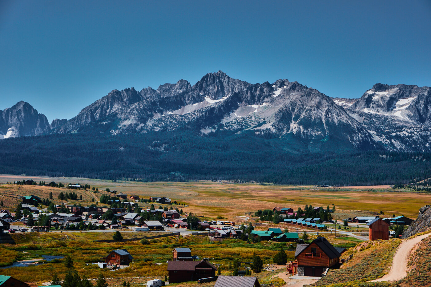
Stanley Idaho with part of the Sawtooth range in view. Thompson peak is to the center left behind the one that looks the tallest
Upon sight of the Sawtooths I was awestruck more than once as each bend in the road showed another knifelike peak in front of me. Hence the name Sawtooths is more understood once one sees them.
Our adventure there started the second night of our trip. After driving all day from Montana we found a National Forest campground about 15 minutes east of Stanley and that is where we spent the night. The stars were so bright I had to try my luck on some astrophotography with my new lens. I snapped a few and crashed shortly after my comrades had retired.

Same Range just further away
We woke early and drove into Stanley for breakfast and coffee, mostly coffee. I wanted to make sure we knew what we were getting into before climbing the peak I had set my eyes on so I had been asking the locals about climbing Thompson Peak. Of course I had also done my fair share of internet research before arriving. Still, the morning of the climb I still stopped at the ranger station to double check. Everything looked good so we set out from the trailhead at Redfish lake. It was now around 10:00am and there was not a cloud in the sky!
We had a total of 13 miles round trip to hike but the locals claim it to be 14 instead. Elevation gain is a tough 4,200 feet. The first 3-4 miles in was very easy and fast paced. After that we took a side trail that cuts left and up a ridge. This is where the climbing starts but it is made up by the views getting better and better the higher you ascend. After climbing for a mile or two it flattens out and there is a small pond. This is where I seen some Golden Mantled ground squirrels running about hoping for some of my food

Golden Mantled Ground Squirrel
Shortly after that at around 8,000 feet we came into a basin with a large lake surrounded on almost every side by jagged peaks. It is a spectacle to behold!

Lake at around 8,000 feet
The climbing commenced again and we went off trail because snow fields had covered it up at this point. Around 9,500 feet after some scrambling we reached the top of a pass where we then made our way around the backside of Thompson Peak and attained the summit.

Atop the pass with Thompson Peak looming in the background
Sitting at 10,751 feet it is one of the more spectacular peaks I have stood on. Thomas Peak is the tallest mountain in the entire Sawtooth range. To the northwest and southwest are the countless other jagged peaks that make up the range. To the west is the valley and on the other side more mountains. To the north is the valley with the town of Stanley looking quite small tucked in it and on the other side of the valley the River of No Return Wilderness stretches on beyond sight.

Looking north from the top. Look closely to see Stanley near the large cloud shadow in the valley

Zoomed in shot looking at the jagged peaks south of the summit
We stayed on top for over an hour enjoying every minute of it. The hike down went fairly smooth and we made it back to the car right as darkness fell.
After some great food from a local restaurant and bar in Stanley I convinced my friends that although we were thoroughly tired and chaffed we could not go to bed before soaking in a nearby hot spring. That turned out to be the best idea of the evening. Shortly after arriving at the spring everyone else there left, leaving us alone to enjoy laying in the warm running water while staring up at a million stars. The spring feeds into the Snake River and people have built small pools for the water to run and mix into the river. Basically there is a pool for about every temperature of water you need. It was not until after midnight that we finally decided to leave our beautiful and restful spot. The leaving was partially due to the fact that as I was laying down in the water half asleep with only my belly and chest protruding something ran across my belly! More like slithered! I think it was a snake. That ended my relaxation there quickly I am sad to tell you.

Hiking down with the sun setting on the peaks
We drove back towards Stanley and found a forest service road leading into the mountains north of the river. We made camp next to a creek a couple miles up. It was near our campsite that I snapped the picture of the stars I have shared with you below. The next morning we broke camp and headed south towards Sun Valley, where another adventure awaited. But that story is for another time.

Stars near our campsite
Even though I spent only two days in Central Idaho last summer it was one of the more memorable spots I visited. If you have a chance to go there do it! You will not be disappointed.
The people of Stanley are hospitable and kind. However, certain areas are extremely busy in the summer months. Places like the Redfish lake campgrounds are booked months in advance. You can find peace and solitude if you are not afraid to go off the beaten path a little and I recommend doing just that. If you do decide to stay in the more popular areas you will still find it enjoyable.
Whether you want to sit back and relax, get lost in the wilderness, fly fish the river, or climb a peak you can find it all in and around Stanley Idaho. See you there my friend!
Signed, a Sawtooth adventurer
Glacier
Posted on November 30, 2017

Looking east from the edge of Glacier Park near Polebridge
Glacier Park! The thought of it is refreshing and pristine as I write this. Montana has many natural gems for one to explore but Glacier is hard for the rest to compete with. How many times I encountered that great wall of mountains rising from the west while driving back from another hitch in North Dakota, I do not know. It was always the first real mountain range I would see. Rising over four thousand feet above the valley floor the peaks tower like a herd of stallions on the prairie with nothing in their way but wide open spaces. Upon sight of them it feels as if one is leaving one world to head into another. The west side of the range rises over five thousand feet in places from the valley also, although it does not look as dramatic as the east face of the park. Glacier truly is another realm to behold with a distinct beauty not seen anywhere else. There are grizzly bear, black bear, coyote, wolf, puma, eagle, hawk, deer, elk, moose, antelope, fish, pika, and many other animals that all live within its ecosystem. If you are lucky such as I was last summer you may spot one of the grizzlies. Me and a group of hikers watched a male grizzly swim on the opposite side from us at Avalanche lake and then walk along the shoreline. It is always comforting seeing the great beasts from a distance rather than up close. The memory of looking at the bear through a pair of borrowed binoculars is vivid to this day. I had not bought a camera at that time so I had no way to capture the giant but I did take some cool shots of the lake with my cell phone.

Me after going under in Avalanche lake

Avalanche Lake

Avalanche Creek
Later in the summer me and a couple friends ventured into Polebridge Montana, a tiny community perched on the edge of the northwest side of Glacier Park. Its about as remote as it gets with no power or cell service with spotty internet in just a few places. We camped in view of a million stars on an old backroad the first night and after a breakfast at the famous pastry house in Polebridge, took the long drive to Bowman and then Kintla lake. Both lakes are long and skinny beginning at the base of the west side of the mountains and stretching northeast into them quite a ways. Surprisingly enough Kintla lake was not as cold as expected so me and my buddies jumped in from dock next to the cabin the rangers stay at during the summer. I took a picture as someone decided to make a running dive into the cold blue water. I will say the traffic on the rough dirt roads going to the lakes is not fun and finding a parking spot can be tough. We got lucky to find one at both lakes. After dinner we decided to head back to civilization but not before I put my drone up and grabbed a shot overlooking part of the west side of Glacier Park. That shot is the headline photo for todays blog.
Glacier can be an exhilarating experience for anyone looking for raw beauty in the remote mountains of Montana. Just remember the popular places are heavily frequented by others so you might have to do some serious hiking or paddling if you want true solitude. I still think it is one of the best national parks the United States has to offer and plan on going back time and time again. What I wrote about are just a few places in Glacier that I have experienced. There are many more things to see and do such as the world famous drive up “going to the sun” road. Trust me on this one, there is a reason its world famous! But don’t just take my word for it, check it out yourself!

Bowman Lake

Lake Kintla

Diving into Kintla Lake
The Sacrifice
Posted on November 22, 2017

The sun rises as another day begins on the plains. I was still working when I took this picture after being out all night on jobs.
As in my first blog I stated that I moved to North Dakota for over three years. Well it was three years and seven months to the exact day. On this article I want to speak of how I got to where I am today to financially be able to live the way most others dream of.
Sacrifice. This is the word that probably best describes what it took in order to live my dream. Just over four years ago I was at a point in life where I knew I needed something else. I had lived in the same small mountain town my whole life and even though I had traveled and worked outside the state a few times, I was at a place where I was not satisfied with where I was at anymore. I had completed my associates degree at the community college in Libby and was working different hard labor and food service jobs to pay my bills. None of this work was great paying though. I had recovered from my devastating knee injury and was ready for something new, something like more college or big money. I chose the money beings I was not sure on pursuing the degree path any further. My buddy David had been working the oilfields in North Dakota for two years at this point and I was finally ready to join! I went to the community college again but this time for a CDL. Even as I was trained to drive truck I worked two jobs. Basically most days I was busy from dawn till dark. Then, just two days after I got my CDL in the mail, I was driving twelve hours towards black gold. The next day I already had an interview and the day after got the call to work hauling production water in a vacuum water tanker semi. David left the very night I was hired so I was all alone housesitting for him on the prairie. He lived miles from Tioga, the name of the small town I worked out of. It was November twenty third and winter had just begun. I could barely shift the thirteen speed I was being trained on and there were snowy roads and icy storms to deal with. There was a time driving home from town that I encountered such a whiteout I drove off the road and had to shovel to get unstuck. I made it back onto the gravel road in my AWD Subaru and very slowly drove the rest of the way home. After much hardship the first few months I made it through a cold winter even for North Dakota standards. That summer I got put onto the night shift and I was happy for this beings night drivers made more money. There were two periods of time during my work in North Dakota where I did not make it back to Libby for almost six months straight because I worked almost every single day for twelve hours or more. During those times I saved, saved, SAVED! I could have bought a brand new truck and did everything to it a guy could want but instead drove a 2001 Subaru Outback. You might think me arrogant or prideful for talking about all the work and sacrifice that occurred and I understand that reasoning. All that really matters though is that you understand that it was far from a walk in the park to live my dreams. You see I had a goal. A goal that took me three years to get to. Then when I hit it I blew past that goal and quit shortly after. I planned my getaway for months in advance and when the time was right I got out!
During my time in Nodak I seen the best sunsets and sunrises anyone could ask for. I should have bought a decent camera during that time but I waited until I quit before buying my gear. I still got some stellar pictures with my galaxy S7 cell phone such as the one posted above. That one was taken while working past my normal twelve hour shift into the sunlight hours. North Dakota is a beautiful and exciting place even if it lacks the mountains and forests I am used to. Every winter and spring the northern lights would come out to paint the sky a light green hue. There is a wonder in being all alone at night on the northern prairie looking north at the green sky. Something about the plains creates a deep serenity inside ones soul that one has to experience to understand. It is also an exiting and scary place to be in at times. I loved watching the countless natural gas flairs burning as I drove down the highway. They shone like beacons in the otherwise dark night. There was a time I almost hit a cow on a narrow highway known as 1804. I also had a couple close calls nearly hitting a moose while driving the semi on the backroads and highways. All of these memories are imbedded onto my brain and remind me of times gone and nights long. But that is past now and we live in the present. Presently I am looking at my next adventure with anticipation and excitement, but thats for another time.
The Journey
Posted on November 17, 2017

I want to start off by telling you how all of this began so you can understand me and why I do all of this a little better. It all started with my grandma taking me on walks through the woods in a baby backpack before I was even able to walk on own and then when I could walk continuing to take me into the forest. Being California raised she moved to the tiny town of Libby Montana with my mother on her own in her late twenties. She has always had an adventurous soul and quickly fell in love with the pristine wilderness of the area. So it all started with nana. I attribute the very beginnings of my love for the outdoors with her. I also had some close friends growing up that lived near me in the woods and we would spend all day climbing trees, exploring in the woods, and building forts only coming in when we were “dying” of thirst or “starving” to death. As I got older me and nana would go on longer hikes and eventually she took me and my younger brother on a backpacking trip. At that point I was hooked! Eventually I began driving myself as far as the roads would take me and be gone sometimes all day climbing peaks and exploring lakes in the heart of the Cabinet Mountains Wilderness. I always felt accomplished after a long day of being deep in the woods and also felt close to my creater in the wilderness. I would say it has always been my element and place of finding myself and resetting before heading back home. I also enjoyed a lot of camping and some backpacking with friends. Leaving the mountains in my early twenties to work in the flatlands of North Dakota was not easy for me but I would take time off in the summer to hike in Montana, Idaho, and Wyoming. I quit my job in June of this year and am now enjoying having the freedom to explore all over the US and eventually the world. I must tell you I have developed a love for the ocean now as well and as I have always loved travel many of the pictures I share will be in places besides just the forest or mountains.
My love for photography started about the time I began going off deep into the wilderness on my own. I wanted to capture the beauty of what I was seeing and share my adventures with others. What better way than with a picture worth a thousand of my own words? Now years later I have a good camera and a portable drone in my arsenal that I have been using since I quite in June to capture my adventures. It is my hope that as you see through my lens something inside of you will come alive and your curiosity, wonder, and sense of adventure will began to ignite. Who knows, maybe it won’t be enough to just see though my eyes